Anyone who would like to see his/her house from outer space is in luck. There are a variety of options available that allow any structure on earth to be seen from space. There are a few things to understand about viewing a home from space before attempting to do so:
Images – The images displayed will not be live. They will be outdated satellite images that have been archived and made available through the chosen source. 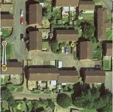
Location – Not all sources will have every location available through their satellite imagery collection.
Data – Depending on the type of data the viewer chooses to see in conjunction with the satellite imagery, various pieces of information such as landmarks, street names, and more may be available.
Clarity – The images being viewed and its source determine zoom capabilities and image clarity. Older satellite imagery does not have the clarity that modern day imagery does.
Bandwidth – Most of the images sent to the computer or Internet enabled device take up a large amount of bandwidth. Downloads may take much longer if the Internet connection is slow.
Websites that Allow Houses to be Viewed from Space
These are some of the websites that allow homes to be viewed from outer space via satellite imagery:
Google Maps (www.maps.google.com) – Google maps is an option that allows structures to be seen from outer space. Simply typing the address into the “search maps” bar takes the user to that location (works nearly everywhere in the world). The more information provided with the address, the easier it is for Google Maps to find the location.
Once the location is loaded in Google Maps, click on the “Satellite” button to load the satellite imagery in place of the default map. The resulting image will be the currently available satellite image for that location. Zooming in with the zoom tool allows a much closer view of the house, any neighbor’s houses in the area, and much more.
Bing Maps (www.bing.com/maps) – Bing Maps provides a simple to use option to find a house from space. Simply search the home address with the Bing Maps interface and it will direct the user to his/her home location map. Navigate the cursor to the “road” tab and select “Birds Eye” from the drop down listing of available options. A satellite image of the location will be displayed and the user can zoom in and observe his/her home from space.
TerraFly (www.terrafly.com) – With TerraFly, simply type the address into the bar and select one of the “Go” buttons. In the United States, the location can be found among the satellite images available on the TerraFly database. Several alternative options in the “Legend” can be overlaid on the map so that information about the area being searched can be easily found.
TerraFly generally has high quality images for major cities. Small, rural locations will not have high quality imagery available for viewing, although an up to date map and information may be available.
Terraserver (www.terraserver.com) – Terraserver is a satellite image search tool that allows the user to input information about the location and search. Simply input the home address, search the location, then allow the Terraserver data to load. Once the location is found on the Terraserver map, high quality images in the form of download, print, or posters may be purchased. There is also a subscription option that allows Terraserver use without any of the image watermarks that show up on the location searches.
Mapquest (www.mapquest.com) – Mapquest allows users to search for any location by address. Once the address is typed into the search field, select the “Satellite” button at the top right corner of the map. A satellite image showing the location from space will be loaded. This is relatively quick and simple to use although the quality of the satellite map data may be low depending on the source of the images.
Flash Earth (www.flashearth.com) – Flash Earth is a satellite imagery tool that allows zooming. The available location search is under the “//search” tab that users click and type an address into. A variety of map sources at the top left of the map can be used.
Note: Using the “Nasa” imagery source will more than likely not allow users to see their home from space. The images NASA produces are usually for tracking weather patterns (such as cloud formation) on the earth, which is updated daily.
Programs to Use to See a House from Space
In order to search for a location anywhere in the world without using a web browser, try Google Earth.
Google Earth (www.google.com/earth) is a standalone application that runs on Windows, Mac, or Linux computers and provides a very unique interface to load available imagery from satellite data and much more. This is a powerful tool that has many capabilities that are not available in the simple Google Maps interface.
Once the program is installed, running the application loads the Earth and allows the user to navigate with the mouse. Alternately, typing in the home address into the search field provides an interesting “Fly-around” from space to the location. Google Earth has many tools that gives users quite a bit of control over what they see (such as restaurants and photographs), which have been listed on the networks within Google. There is a free and paid version (a business license) of Google Earth available.
Google Earth also offers a sky option that allows users to scan the sky for stars and other celestial bodies. This is a great option for those who wish to look at more than just the Earth.
Another alternative to Google Earth is NASA World Wind, which is a comprehensive virtual globe that is designed to allow users to easily navigate the Earth with a variety of options in satellite imagery. Using World Wind software from NASA is very similar to using Google Earth. The only real difference between Google Earth and NASA World Wind is the fact that World Wind is an educational tool that offers an immense amount of features and is completely free.
Installing the program is quick and easy to do. Required DirectX component files will be installed if needed. Once the program is installed, running is simple and takes a few moments to initialize. Depending on the video card and capabilities of the computer that the NASA World Wind software is installed on, the speed of viewing the virtual globe will vary.
Notes about Viewing a House from Space
It is important to remember that there are no options that allow a “live” view of a home from space. Night time data is not yet available with any of the options, but may be implemented later on if the need and interest are high enough.
Depending on the viewer’s Internet speed, satellite images may appear blurry for a long period of time until they completely load. Many satellite imagery options will only have low quality and resolution options that show very little detail about locations that are viewed. It costs too much for companies to make it possible to zoom in closer than a few hundred yards. Also, doing this and downloading so much data would take up an immense amount of bandwidth.


Follow Us!